
the hills of st pierre and st andrew 1756
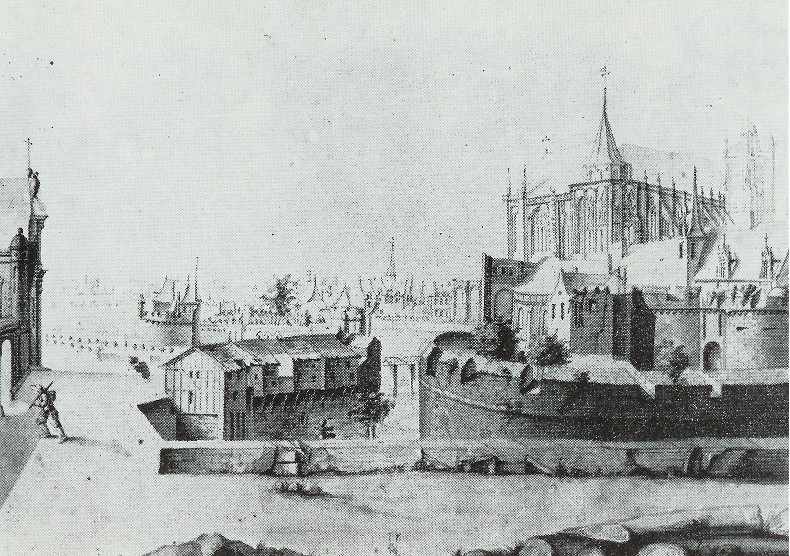
The hills of Saint-Pierre and Saint-Andrew were so completely modified during the XVIII century that
it is very difficult to imagine the old state of this district. A drawing below (1) represents the old
strengthened enclosure which defended the city towards the east (it acts as a late copy according
to a drawing of Jacques-Andre Portail preserved at the Public library and whose Municipal Archives
have another version by Robert Seheult II from August 6, 1756).(1,2) Both copies originated from
the archives of Saint-Felix Seheult and were in his possession until his death in 1858. (2) This
drawing "shows the perspective of a part of the town of Nantes from the side of Mote St-Andrew,
made by Seheult on August 6, 1756". It is a “Splendid wash drawing giving, in the foreground, the
St-Pierre gate and the foundation of the cathedral and in the background, the château." (2)
References
1) Iconographis de Nantes: D’après Les Collections du Musée. Musées Départementaux de Loire Atlantique:
Musée Dobrée; Nantes 1978. pp 31 (#44 pl. XVIII)
2) Municipal Archives of Nantes: Series II 174
Image: Iconographis de Nantes: D’après Les Collections du Musée. Musées Départementaux de Loire Atlantique: Musée Dobrée; Nantes 1978.